Alaska, Round II

Doug Bowen and I are about to take Alaska by storm. We both recently retired, and we want to take my Astro Van with 160000 miles on it and pull a small trailer with two small dualsport bikes all over the Great White North. I'm hoping to get to Inuvik, and Doug is hoping to get to Nome. We will see.......we will just do it!

Friday, August 04, 2006

Day 23 ad 24, Bella Coola

Bella Coola, British Columbia
So As Doug and my trip was winding down we found a little more time to make a run out to the coast at Bella Coola. We had gotten into Williams Lake at around 5pm, and decided to make a Hundred miles of HWY 20 that evening.

You have a tendency to think that once you have left the northern parts of BC and Ak as well as the YT, that the best parts of the country are over for you….But that isn’t true at all. The ride west from Williams Lake is more open country with deep valleys and fast rivers, and tall mtns. Lots of forest that are not obscured by trees along the road.


The bark beetle has killed miles and miles of pine trees, but so far it has only added color to the scenery.

We had passed the last gas station in Williams Lake without realizing it. I knew there was a gas pump/ cafe/convenience store at Hanceville, fifty miles away. The trick was would it be open on this Sunday evening.

As we drove along, I noticed a lot of new signage along route 20 that hadn’t been here last year. There were signs touting gas a places down toward Lillooet (a hundred miles of dirt roads away). They made me wish that we had time to take the bikes of for exploring, but we kept to the plan of a quick trip out to the coast and back.

We arrived in Hanceville 10 minutes before they closed. Gas cost us a few bucks more, but we were happy to get it. Bella Coola is about 275 miles from Williams Lake, so a fillup now was much appreciated. The gal that had the store open was nice enough to make us a sandwich for dinner, and we noted that she held the gas pumps open for a couple of late comers. They are very accommodating out there, in those remote area. A side note is that Hanceville was opened up in the late 19th century and has never been closed. It’s a one building town, but it has loads of personality.

Doug drove us for another 100 miles before we decided to pull off the road for the night. We found a stream to set up by, and we called it quits at about 10pm. We were far enough south by now that there was a dusk at around 10pm.

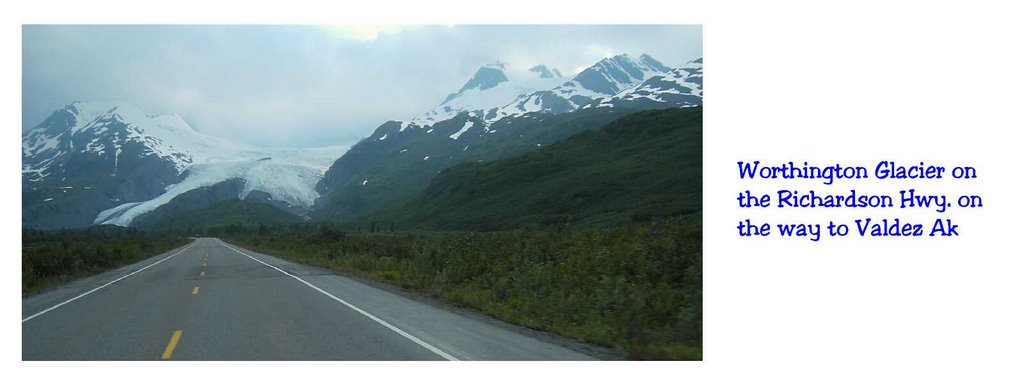
I had promised Doug a great ride today. We were on the bikes by 8am and headed for the coast. There would be another 205 miles of pavement and then There was 60 miles of dirt, and then 40 more miles of pavement once we hit the valley floor at the bottom of ‘The Hill’.
It was brisk at camp that morning as we were at about 4500 ft, but we were dressed for it. Hwy 20 is a shipping route for that part of BC. Things are shipped in and out, which means there are quite a few semis on that road, and they all know the road very well. It is wise to be ready for them, because they are flying.

But more amazing than that, is ‘the Hill’. It is a 5000ft drop on a sometimes one lane hard surface dirt road with a half dozen switchbacks. The ride has great scenery and it isn’t unusual to encounter bears and other wildlife along there. Of course there is very little traffic on ‘the hill’ so as I went down, I wondered just how fast a fellow could get up that hill….Hummmm

So Doug and I did the 120 miles into Bella Coola by about 11am. We spent an hour down at the harbor and the park at end of road. Saw some falls at a hydro plant out there. We also had lunch in town and talked to some Visitor Center folks.

Near the bottom of the hill are some falls that fall about 500 feet or so. They have a bunch of great pictures of them. The catch is that its about a 12 mile hike to go see them. In my time in town, I only found one person (a gal) who had ever actually seen them. Walking….hummmm…..I don’t know about that.

As I said last year…..
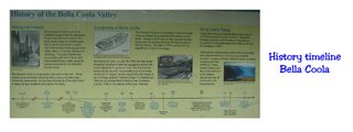
Bella Colla has a 10000 year old history. You would think it was a hundred year old town now, but the indians have been traced back a long time. A funny thing , Captain Vancover arrived there by sea in early June of 1773 and coincidentally Mackenzie arrive there overland, just 6 weeks later, in mid July of the same year. The Indian must have thought, "Holly cow, the neighborhood is really going to hell". Did I say it was a small town? Well it is...500 tops………

So after lunch we were back to the road out of town. Another nice ride to the bottom of ‘the Hill’, then as I planned, I rolled into the corner at the bottom and noted the time on my watch. I had made up my mine to set a record on a climb to the top.

Since the road was a good road and wide if your on a bike, it could be done fairly safely. It’s surface was hard with lite sand most everywhere. There was usually a no sand track along most straight-aways, but the corners and switchbacks were sand cover hard surface. Read slippery as hell in the corners.

It was quite a challenge as the remoteness meant that you couldn’t error. That meant slowing for the corners was tricky and exiting the corners was tricky, especially as you got a little higher and you could see off the guardrail less cliffs.

The road was right at 11 miles to the gate at the top. I don’t know what bike would do the best on that hill. My DR350 was certainly under powered for the task, so it was pretty easy to not 'go too fast' as you might on a sport bike. And accelerating out of the turns was a delicate task. Anyway I checked With Logan who has a resort there on Nimpo Lake, and he said no one else has clocked a time on the hill so I now have the record at 16:18 minutes.

It got my heart started for sure. When you are approaching one of those hairpins at seventy, and you have to do your braking down to 15mph on ballbearing, it will put a lump in your throat.
Ah, it’s nice to be a record holder…and it will probably hold up till someone else tries to do it. That could be years.

We both cleared the top of the hill, and made it to the Van by 3pm. That left us enough time to travel to Williams Lake and much further south for the day. But before we left Hwy 20 we had time to stop at an old native grave yard for a walkabout. This was near the Redstone reservation. The inhabitant’s lives ranged from 1850 to 1950. One of the older and more decorated grave was Chief Charley Boy, who lived from 1873 to 1951. There were lots of Charley Boys in that graveyard. I wondered how they came by that name.


…….and so it was as Doug and I pulled the shade down on another day. We eventually ended up at 100 Mile House for the night in the back of a defunct Husky gas station. I didn’t think that required a picture.

Saturday, July 29, 2006

Day 14 and 15 in Dawson City, first time


This morning I slept in and caught up from 14 hr days on the road. Since we got alate start we decided to do the cultural thing in Dawson City.

There was the mining and history museum to start with. Now let me tell you, Dawson City is a restored bunch of old mining type business buildings, and more new buildings trying to look old. When first I visited there in ’05, I snubbed my nose at the yuppy type of restoration as I drove hurriedly through town.

....But this time I went to the museum. There was a cute gal that narrated us through the period of the gold rush.

Then there was a 30 minute movie done in the late '50. I sat through 'City of Gold' What a
movie. By the time that I had suffered the miners trip from Skagway, up over the Chilkoot Pass, and then down the 400 miles of water ways to get to the gold, I was a believer.

Those guys earned whatever they get/got out of those hills, be it a buck from us tourists or from what little gold is left in the streams.

So we spent the rest of the day looking around town at the Dawson City Visitor center, and the North West Territory Visitor center. We spent an hour with the Eskimo girls at the Inuvik (NWT) VC. What a hoot they were. Doug was really getting hyped up over the, soon to be, ride to Inuvik, as was I.

We learned that there were 250 stern wheeler river boats running on the Yukon River at one time. They even had a grave yard for old out of service River Boats. We found it, and walked around the old hulls for a while. These things were a couple hundred feet long, but were mostly a pile of wood and old boilers. They hardly looked like boats any longer, but I could still here the captains calling out orders from the past.


There seemed to be a number of 'around the world' bikes gathering. There may be a large assault on
the 'Dempster Hwy' (road to Inuvik) in the making. Today was Wed, and we learned that there was a bike gathering to happen over the coming weekend. I'll bet my DR350 and Doug’s NX250 will impress the hell out of them. :) We planned to be on The Dempster for Thursday and Friday. Maybe we would be back for the Weekend bike event.

Getting advice on whether to take the road or not is all dependent on the weather, and no one seem sure of what that will bring. There seems to be some real slick clay sections that are like Ice if it is raining.

Our 'go' decision will likely be made in the morning when we look at the sky. At any rate, the road is about 450 miles long. There is gas at the 232 mile mark. If the road isn't slick it is cake, but...... The best we could do is a day up and a day back. I imagine you won't hear from me for a while longer than that.

Well that was quick. We got out to Klondike Corners, where the Dempster starts, and had gassed up. While we put on the last of our gear a fellow comes over and asks if we are headed for Inuvik. We say yes, and he says that he was up there for a whole day waiting on a Ferry to take him across the first river.

He says that the river has risen, and the ferries will not be running for a few days. In another 15 minutes we would have just passed him on the road, and would have learned all that the hard way. So that burst that bubble. Doug and I went to Plan B to head over to Alaska, to see Valdez, Homer, Anchorage, and etc…..

Thursday, July 27, 2006

Valdez and Kennecott, Day 16 and 17, I think


We pulled into Valdez this morning. We spent the night at the base of the Worthington Glacier on the side of the road about 40 miles from Valdez. Valdez is pronounced Valdees, and you will be told if you pronounce it the normal way. Fu#king mosquitos have found a way into my van via the heater ducks or somewhere.

They are having some success, as when we squash them they show signs of being well fed. I need to spend more time cleaning the inside of the windows than the outsides.

Anyway the ride down to Valdez is as scenic as they come with lots of glacial waterfalls washing down from the mtn cliffs, then we follow that water into town along the stream beside the road. I was of the opinion that Valdez is an oil town and would have little tourist value. You do follow the pipeline some, but most of the time you can’t see it, and you never see any oil managing plants once in town. It is worth the drive to see it.

We made a quick trip into and out of town, but before we got to town. Yesterday, we unloaded the bikes and went into the Mckarthy /Kennecott copper mine. It was 60 miles of dirt road that followed the old railway to the mine. Great stuff. Much easier than taking a car in there.


They are trying to make a tourist attraction at the copper mine, which of course it is, but they have problems. There is lots of private land up there. The national parks are in control of the Wrangle Mtn Range. But they have a treaty of some sort with the local owners that says that they have free run around there, even in vehicles.

So first when Doug and I ride up to the beginning of the interesting stuff, there are all sorts of parking concessionaires that want you to pay for parking. Then they want to shuttle you around for more money. It is a mile across a river to the old town of Mckarthy, then it is 2 more miles up to the mine, and another mile to the glacier beyond that.


We can ride across the walking bridge (strong and big enough for a 4 ft wide 1000 lb vehicle), and skip all that concessionaire stuff, but we get long looks from the folks that we aren’t paying. Last year when I was there, there were no organized parking lots. They will figure out, soon, how to make everyone pay, but they haven’t got it worked out yet……but it coming….ah, don’t you just love progress???

We can ride our bikes all the way to the mine. The road goes to the glacier, but the law says that only local owners can use those roads. Tourists have to walk. That sucks. I had a long talk with a gal park ranger who explained all that to us.

Kind of funny or sad that up there you can have quads, motorcycles, bicycles, and hikers all on the same trail, but down here it takes a different trail for each of those venues. I would have liked to ride up to that glacier, but I wasn’t going to walk up there.

I look at a dualsport bike as a ride for the handicapped. I can’t walk for miles to see things. Do you think I could get a handicapped sticker for my DR? Who would I ask about that. 

But she also explain what all the rock piles that were strewn for miles around there were. I had assumed it was talus piles from the mine, but it wasn’t that at all. It was what was left behind when a glacier recedes. You see a glacier carries rocks along with it, and it dumps the rocks at the end where it melts. It melts in the same place for years and there is a big pile of rocks left there. As it recedes, it dump more rocks there, and this is one way get miles and miles of piles of sedimentary rocks.

Now you know where all that gold up there came from. The glaciers move a lot of ore around, and break it all up and the heavy stuff (gold) all works its way down to bedrock. All you have to do is work your way down through the permafrost, and pick it up. That’s hard work though, and there have been a lot of others there before you.

All that BS aside, Doug is feeling more comfortable on his NX250. At one point where they were doing road work to widen a section of that dirt road, they would blast and then load the rocks in a large ore truck so we had to wait for a spell.

There was a sign that said 'prepare to stop'. Doug was leading, and he was approaching a large water truck who was barreling at him. I could see they were both going to get to a narrow spot in the road
at about the same time. Doug just nailed it, and got there about 30 yards before the water truck. He squirted through safely, and the water truck never slowed.

Cool. The significance here is that the water truck driver gave Doug a high sign of approval, instead of the 'what the fuc& are you doing gesture', that I expected.

Its the way the 'Great White Northwest' is. You do your thing, and I do mine. If you didn't cause any real problem then it is approved of. Everywhere we have gone the dualsport bikes are approved of. Even after you roost someone they are still waving and have a smile on their faces

We were loading the bikes back on the trailer after yesterday's ride while a town cop was driving by. I thought that maybe I shouldn't have parked where I was, but no, the cop just wanted to take a closer look at the bikes, and he had a happy face and another high sign for us as he went by.

It's different up there. So we saw what we had time to see, and left the mine for Valdes.
We stopped at a café for a burger not far from where we loaded the bikes. Up there thay take an old house and make a café and convenience store out of the place. This one had been converted long ago.

We enjoyed a great burger and got to talking with the proprietor. She also has a cute daughter of about 10. Anyway the gal had the place up for sale. She had had enough, she was heading back to Arkansas as soon as she could. It is like that a lot up there. It seems so peaceful…..and perfect, I suspect, until the realities of a few years up there grind you down.

There was a 30 year old guy and his wife in there talking to us as well. They lived in Alaska. He was full of enthusiasm for living up there. He was beside himself over an antique crosscut saw that he had just bought at an antique store near the copper mine. He paid 200 dollars for it. Some folks I’ll just never understand. Clearly a case of having too much money. Nice guy though.

Remember we were on the Denali Hwy when we decided to go to Inuvik. Well, we had been at Homer, about 150 miles west of Anchorage. So there we were trying to get to Homer Spit one evening. It was about 10pm. The sun ws still 30 minutes from going down, and it was the time that animals are restless. We were running 55 with Doug driving. He likes to drive, I like to look. It works out pretty well that way.

Anyway a yearling moose jumps from the side of the road at full tilt. He's the size of a full grown deer. He's looking at us, and will make it by us with 20 yards to spare......but he ain't watching for cars coming the other way, and that compact car coming from that direction was much closer to him. In fact there was an interference fit on that side of the road.

I saw the whole thing like it was in slow motion. The moose was between strides and the car hit it in the legs, which pushed them out from under it and the body just laid down on the hood of the car, then it was already rotating, and it rolled up the cars windshield and onto the top, then off to the side.

It all happened in a flash. We didn't stop so don't know the damage to the car. The moose staggered to it’s feet and ran off. All I'm sure of, is that, that moose would have ruined my day. We aren't hurrying anywhere anymore.....still....Luck beats good, eh.

So homer is a cool place on 4th of July weekend. A regular spring break type of place, in Alaska. We drove on into Homer that evening. We stopped at a View point about 3 miles before homer and took pictures. Note the sun is still shining.

There was a sign at the view point that said a lot. I divided its message into 4 inserts, and included them as pictures


We drove on into Homer that evening. We stopped at a View point about 3 miles before homer and took a picture.

So we found a place to park on Homer Spit. They would like to make everyone pay for something down there either parking or a campsite. We found a place that was free, of course.

In the morning we drove around and looked for wifi. Homer has it but you need to subscribe. But we found an internet café that let us use their puter/internet for free. The place was called the ‘Spit Sisters’. Run of course by two cute girls, sisters I suppose.

We ran around Homer and looked at the scenery of giant mountains across the bay covered with snow and many glaciers. We talked to one of the Spit Sisters’ boy friends. He was commercial fishing off a 35 foot boat, and had been kind of abandoned by his deck hand. He was looking for another before he could go fishing again., yada, yada, yada……

So we were off then to Hatchers pass and things that we hadn’t seen yet. As we were driving into Anchorage. I started to feel a thump, thump. I asked Doug if that thump was getting worse, and about that time the bubble that had been growing on my right front tire exploded and tread separation began flapping badly. Damn, and it was Sunday of the 4th of July weekend.

The tire hadn’t gone flat so we drove around to a near by Cosco to get a new tire, but the customer in front of us was the last customer that they would take for the day. So we put the spare on and left, deciding to wait till Monday or Tuesday to get that tire replaced. That left me with no spare except the tire separation tire. Well, that tire would have to do. It still held air.

Off to Hatchers Pass for us. Hatchers Pass is a state park, I think,. Its about 30 miles from Anchorage and it is an alternate route to Denali. Its a dirt road only about 30 miles long. It goes from sea level to 5000 ft in no more than 10 miles.

I surprised Doug with this one. He let me do the maps most of the time without question, and his jaw dropped when he got to the top for that breath taking view of the world.

We camped up there, and ate a couple hot dogs for dinner. Do you notice that I’m hardly talking about animal sightings anymore. Oh, just another moose, no big deal. Oh just another bear. Did you see those deer back there, yawn.

Saturday, July 22, 2006

The return to Dawson City


We got out of the hotel at 11am. It didn't take us long to see town, such as it was, and get a couple coffees and a muffin down. We had a great conversation with a 40 year old female artist. She was also a rider. She had a VFR, bur wanted to trade it for a KLR.  Smart girl as the 550 lb VFR with no off road suspension isn't right for a 120 lb gal.  She was doing some avant-garde paintings, mixing the mystical with the animals of that area, and the First Nation folks from up there.

We gassed up and visited the church as well as the native visitors centor. The church was ok, but the visitors center was spectacular. Turns out that an 18 year old niece of Nadia Lennie, a Dawson City visitor center gal, was the host for the day. She was really beautiful, and nice to boot. She explained some of the culture, and the outer island in the Arctic Ocean. She whipped Doug and I up a certificate that said that we beat the Dempster on Motorcycles.


But time was a wasting, if we wanted to get back to Dawson today. We had already gassed up, so we left the VC at 12:30pm. The sun was shining, but it was still cold, in the 40 degree range. I had stuffed some newspaper in my chest area, and closed up any air gaps around my neck.

My groins had recovered, but I could feel the pain was there just waiting to return. I didn't see any way that we could do better than Eagle Plains today, but the road was good and the wet part had dried out to just a few puddles. We did the two ferries, and gass up in Fort Mcpherson, in just 6 hours.

Although cold, we we're sitting in EP having a burger at 7pm. There were several other bikers there. One was a PC800 that we had passed on the way up yesterday. He had had a flat tire and was forced to go back to Dawson City. He was here now, spending the night, and on the way to Inuvik..

As we ate, we talked to some folks at the next table who had come up from Dawson. They said that the rain that we were going into wasn't too bad. Rain!!!...we didn't want to hear that. We had imagined that it would just be another 5 hour leg and we would be back in Dawson.

So we geared up and left with apprehension as our riding partner. We had to make Dawson tonight, as the gas station at the highway would be closed. The gas can that Doug had put the hole in would still hold gas, if we filled it, and then strapped it on Doug's rack with the hole up. We figured we would go 50 miles and use most of that gas right away. We had 23 more miles to do than on the way up to get all the way to Dawson City since the gas station at the road at the finish of the Dempster would be closed.

The folks at the next table were right. It started raining in less than an hour. Still, it wasn't hard, but the road was sloppy wet, and oncoming traffic was going really slow on the hills in both directions. Most of that was Semis with trailers. I remember passing one semi going down hill. Of course, he was in the tracks, and I had to make my pass out of the tracks, in the fresh untraveled roadway. I wondered how slippery that would be, and just how I would fair rolling around under his dualies in an extreme situation.

Well, 'no harm, no foul' or 'luck beats good. My bike's traction held up. At one point Doug waved me on ahead as he realized that he was holding me up a bit. I finished up the mountain section and then waited for him. That left about 60 miles left to the pavement, and the rain was over by then.

You can see that we were all about the business of getting back to civilization, as there are no pictures being shown.  It was late and we were cold and tired.  Yep the thought of pictures did not come up.

Doug went ahead from there. I was prolly about 30 miles from pavement when I ran out of gas. Doug got 80+ mpg with the NX, where I didn't quite get 50mpg. Doug didn't notice that I was missing, which is what I worried about on the way up, but I still had my two gallons of gas, so it should be no problem.

It was about 12:30am as I poured the gas in. I'm not really used to running out of gas in this bike, and I don't know the drill for restarting that bike....and I still don't know why, but it wouldn't refire. Oh shit, quickly testing, showed that I had spark, and gas going to the carb as well.

My starter button had quit working a few months ago. I put a starter switch in the line that bypassed the starter switch. As I ground away on the starter, I realized that my starter button didn't cut out my headlight. I could hear the starter getting slower.

Doug hadn't come back so he probably was at the pavement waiting some thirty miles away by now. He wouldn't have enough gas to get back to me, I thought. If this thing didn't start in the next try or so, I was going to be in a serious pickle. I'm sure it was the last bit of juice in the battery that began to ignite the engine. It started as though it was flooded, go figure.

Thinking back, remember how I said we put our reserve gas in the bikes before we ran out on the way up.  Well, I should have stopped on one of the many hills and done the gas transfer before I ran out as I could bump start on the hill if I had to for any reason.  That would have been just an extra bit of insurance in a worst-case scenario.  I didn't because I thought Doug would be there to pull me if my bike wouldn't start with the starter.  That little laps of not being as careful as could be, could have gone downhill, especially if any of the wildlife got involved.

I can't emphasize enough that in remote places like Baja or up here, or lots of other places a rider is relying on his partner, and doing anything that lets your partner out of site can be catastrophic if just a couple of negative coincidental issues line up at the same time.  This time it worked out all right.

30 minutes later I pulled into Klondike Corners where Doug was waiting. Doug had gassed up as someone else had paid the opening up charge of $10 (that we didn't know about), for an emergency fuel up. He was glad to see me. I suspect that most remote gas station in Alaska have an 'open anytime' charge up there.  That's good to know.

We drove the last miles to my van in Dawson City, and arrived there at 2am. That van was a sight for sore eyes, and Doug and I didn't chat about the trip much before going to sleep. Doug's new name has been forever changed to 'Muddog'.  He cleaned the mud off his duds as soon as he got up.

Friday, July 21, 2006

Demster Hwy, the devils road

I’m jumping forward to our ride to Inuvik over the Dempster Hwy…..

Doug and I had been to Dawson City, YT a week earlier (than now). We had nearly been rained out, but the morning we were set to take our dual sport bikes the nearly 350 miles north to the Arctic Circle and a 150 miles beyond to Inuvik, we were stopped by ferries that were out of commission. You see there are two river up there, the Peel and the Mackenzie, that must be crossed by ferry.

About early June the ice has melted and the rivers have slowed enough that a ferry can operate on them. And of course, when the rivers are frozen thick enough you have an ice bridge. If the river rises due to rain and too much debris, it will shut the ferries down for a couple days or more.

Interesting is that the rivers up there all ice over in the winter, but the peculiar thing is that the ice clears in an instant. The ice breaks up on each river at a different time, but when it happens, it resembles the rear window of a car in a hot sun. The locals even bet on when it will happen, right down to the minute. It’s kind of a Yukon lottery.

As we were driving toward Fairbanks after having toured Hatchers Pass, We found ourselves on the Denali Hwy (from Cantwell headed south) feeling sorry for ourselves because we failed at the Inuvik attempt a week earlier by those ferries being shut down by high water. We found ourselves grousing about not getting to ride the Dempster Hwy. We noted that the weather was clearing up, so we called the girls at the Yukon Visitors Center when we got some cell signal, who said that the ferries were running again. So we decided to go back over the ‘Top of the World Hwy’ and make a run up the Dempster in the present good weather.

We got as far as Chicken, that night, which left only a couple hours into Dawson City. Once in Dawsom the next morning, we used the rest of the day to get our bikes packed for a couple days on the road.

I wanted to be able to spend a night on the road if we should have to. That meant sleeping bags, a tarp, tools, bug spray, and food. Oh, yes, and we would each need an extra two gallons of gas.

The logistics are that it is 232 miles to Eagle Plains from the turn off 23 miles south of Dawson City. With 2 gallons extra I have 300 miles of range. Doug had 280 miles of range with his NX250 with an extra 2 gallons. It should be easy to average 40 mph, or just about 5 hours to get to fuel at Eagle Plains.

Then the other side of Eagle plains is a similar distance, but with two ferries. So add another hr for the two ferries. We should make Inuvik by 7pm with an 7:30am start. A little longer if we dawdled.

Since we had that all figured out and planned for we went into Dawson for a walk about, and to see what was cooking. A bus tour had been in that day, as most days, so there were twenty or more tourist milling around. There were that many locals doing what not.

Doug and I settled down on a couple chairs on the boardwalk to see if we could learn anything.

We sat there and watched the world go by, and talked to the old timers. Ralph Nardling talked on and on about the gold History, and what he was going to do to revive gold mining, and J J Deberg told stories.

Apparently Dawson City had quite a past where ladies of the evening were concerned. There was one gal in particular who was named 'Liberty'. It became a local saying in those parts, that if something went up and down a lot of times, you would say that it went up and down more times than 'Liberty's drawers'.

J J (a 75 year old Firt Nation man) was a card. He even found time to work an attempted watch sale into the mix. Still, I liked the old guy, and respected him the more for it, I think.


Dawson City had 40000 folks living there in the second year after the gold strike. It was discovered in the fall of 1896, word got back to the states, and the rest of the world in 1897, and folks that were hungrey for a fortune made the trip up there during the winter of ’98, in order to be there when the weather was good the spring and summer of ’99.

That meant they traveled all winter, and winter up there sucks. Typically they would sail into Skagway and carry, somehow, their supplies about 100 miles to a lake on the other side of Whitehorse, where the Yukon River flowed out of on its way, 300 miles, to Dawson City.

There is a mtn pass outside of Skagway called the Chilkoot Pass
Where the mounties would wait. You had to have a ton of supplies with you or they wouldn’t let you go on to that lake. The last of this pass was about a 1000 ft tall, of steps chopped in ice at an incline of 45 degrees,. You had to carry that ton in multiple trips up that mountain. There were 20000 men in Skagway trying to get in that line 20 times carrying a 100 lbs up that 1000 ft.

When you finally somehow got to the Yukon River, you had to build a boat to float down the river with your ton of supplies which you'd carried a 100 mile from the pass…..and when you got to Dawson City you would find that all the claims were already taken by Alaskans and others that were much closer when they heard about the Klondike Strike.

Sometimes life is just the pits.

…….But enough of all this history crap. We stayed on the boardwalk till around 11pm. It was still light outside, and the temp was about 65 degrees. It had been sunny all day and we expected clear sailing in the morning. We called it a night and went to bed by 11:30pm.

The sun was long up by 6am when we got up. We strapped the stuff on the bikes, and had time to get some breakfast at the RV park café. There was a gas station 23 miles out of town where we would make the final turn onto the Dempster Hwy. It would open up at 7:30. We needed to top off there so we left a half hour early to make that 7:30 gas connection.

It was brisk at around 50 degrees, but it would warm up quickly once the sun got into its act. I was dressed with all my coats on already. Doug had his stuff on except for his rain gear. As we left Klondike Corners it was still brisk. The road was good. Everything was a go.

We rode for an hour or so before we took a break. The sun was still shining, but it wasn’t getting any warmer, I didn’t think. We pulled into a rest area overlooking the Tombstone Valley some 80 kms up the road, we had been running 60mph.

I was trying to run beside Doug. The philosophy being that that kept us out of each other’s dust, and both of us would likely notice the other one missing especially if the trailing guy had bike trouble. When you have a gas situation you don’t need the other guy running 20 mile before he notices that he has to come back and get you.

But that made Doug nervous as he was unsure of himself on gravelly roads. He told me to either go ahead or hang behind, but not to hang alongside of him. Oh well, whatever, so I was behind from then on which would be alright if nothing went wrong.  I tried to stay close to him until I took a piece of gravel to my lip.  I dropped back after that.

At a small construction delay we stopped and I noticed that Doug’s gas can had fallen off his rack and was leaking gas from a hole rubbed in the plastic contain by the tire. There is a rule that says, a fellow should get his auxiliary fuel inside his main tank as soon as he can, because there are way to many things that can go wrong with fuel in a gas can.

Luckily Doug had only lost a pint of gas, and we divided the rest of it between his and my tanks. We were lucky that we were stopped by that Construction stop…..and did I say that we still weren’t getting any warmer.

I was shrugging my shoulders for a better seal under my helmet, and clenching my legs to my gas tank. In fact, I needed to relax those muscles to get an ache to go away……and we noticed some darkening clouds in the distance. Hummmm, I wonder if we will be going that way. We put our rubber boots and gloves on just in case. Note how clean Doug's rain gear is.

It wasn’t more than another 15miles, and we were riding in rain. Not a hard rain, but the road was wet as hell. It wasn’t really slippery to my bike, but it made Doug all the more uneasy, and he slowed his pace to about 20 mph.

The wet made things even colder. At one point, we stopped and put the rest of the fuel in our tanks. We didn’t want to run out, and have to do it under stress later somewhere in a bad situation. That got us to Eagle Plains at about 2:30 pm. That was about 7 hours instead of 5.

We both were cold and miserable. It was sure nice to get into the warm gas station office just to pay the bill. Eagle Plains is a lodge/resort. There is a convenience store, a restaurant, and a motel. It seemed like an oasis to me. I could have stayed there for the next week.

Other drivers came in and said that it was snowing at the 4000 ft pass that lay ahead of us. We thought about that as we had a burger, and warmed up. We weren’t in any hurry to leave the comfort of the lodge.

A fellow on a 650cc BMW was there, who had left earlier than us that morning. His bike was parked down the way like he had gotten a room. We tried to look him up, but couldn’t get a rise out of him when we knocked on his door. The last thing he had said, yesterday, was that he might do the whole ride both ways if he felt good. My guess was that he didn’t feel 'that' good.

Doug was bent on continuing. I was going if he was going. We suited up and hit the road at about 4pm. The rain had stopped, but the road was sloppy. Mostly there was grit under the tires that provided traction. The waitress gal said that she heard that the next few miles was the only slippery part.

Apparently, they lose some trucks and campers off the side of the road a few times a year when its raining. We didn’t really see any slippery clay type mud….for a couple miles. One time when I looked up the road, Doug and his bike were lying down in the right hand track. I rode up in relative security, because I was in the left track. That was the whole difference as to whether it was Doug or me lying there in the mud. It was clay type of slippery in the right track and not the left track.

We pulled his bike up and straighten his gear shift a bit. There was no real damage as it had been a slow speed drop. That made Doug all the more cautious, as he should have been. He had mud everywhere. It was all over his gloves. He couldn’t wipe his faceshield. He couldn’t even hold onto the throttle very well.

The rain had started up again lightly, and we rose into a cloud as we climbed to that pass where it had been snowing. We stopped at the Arctic Circle for a couple of money shots. Note that Doug’s suit is a bit soiled.

After a bit of a warm up, we drove on. We drove into a cloud up at the pass, and the temperature dropped at least 5 more degrees. Doug couldn’t close his faceshield, because the fog/sprinkles couldn’t be wiped off with his muddy gloves. Doug spent at least 30 miles freezing his lips off. Before we got back down to lower altitudes.

At about 10pm we drove into Fort Mcpherson where we could gas up. Of course it was still very light outside, so that we didn’t know how tired we were. We hit the last river at about 11pm. The last ferry is at midnight. We were about 100 miles north of the Arctic Circle at 12pm, so we truly got to see the ‘midnight sun’. We both had gone a whole lifetime, until now, without that pleasure.

Inuvik was a little over 100 miles of good road from here. We had had sunshine in Dawson City when we left, and there was sunshine in Inuvik when we arrived. The only problem was the cold front and the two storm systems that we went through on the way. I had never gotten over the hunching of my shoulders or the clenching of my legs from the cold. My groins were aching, and my neck was stiff. Doug and I could hardly get our legs over the bike when necessary.

We had spent most of the day at sub 40degree temps, and me with electrics back in the van. I had reasoned that it would be so warm that electrics would just get in the way. What a dumbass.

We arrived at the hotel in Inuvik at 1pm Yukon time. It was 2pm Northwest Territory time. Hey, that was our first time for being in the NWT. The trip had taken us about 17 hours….and check out time of 11am was just 9 hrs away.

Oh, yeah, it was worth it, and the hotel room, at 134 dollars for the night, was worth it too…I think. I might have paid that $134 just for the hot shower.

If you want to compare the road to Prudhoe Bay to this road to Inuvik, I would say it all depends on the weather, but in the end the Dempster Hwy is more challenging.

Thursday, July 20, 2006

Day one, The real story

The History of Alaska and Canada in the northwest is something to inspire. The beauty of the country and the hardships dealt with by the men and women who settled there to carve out a life, will live in my memories forever. I heartily recommend that you don’t take my word for it. Get up there and see it for yourselves.


As you may remember, I traveled to Canada and Alaska in 2005. Doug Bowen, who I’ve known since the 8th grade, was going to go with Bill Warner and I last year, But Doug, had a bout with appendicitis and colon surgery. It damn near killed him, but thank to the miracle of medicine, Doug was a 100% ready for a trip this year.

I learned last year that riding around Alaska, a sometimes cold, rainy place, can be done on a motorcycle, but can be also done in a closed in vehicle as well. We decided to go in my van, and pull two small motorbikes on a trailer. The motorcycles would be used when the roads were rough, and the weather was good.


The Van was well broken in, to say the least, but it is a good running vehicle, and we decided that if repair was necessary, it would just be part of the adventure . Doug suggested that we put new tires on it before we left, but I said that we might be able to do the whole trip on the tires that were on it, and that we could put tires on it when we got back if necessary. I should have listened to Doug on that one. But, hey, nobody is right all the time


So it was That Doug and I departed on our ‘trip of a lifetime’. We hit the road at around 9am on the 15th of June 2006. It was within a day or two of when Bill and I left last year for Alaska. This time it would be mainly in revue for me, but a whole knew experience for Doug.

We soon were talking excitedly of our new freedom. It’s funny how our lives at home are probably what we want them to be, but at the same time, a new trip on the road released the boy in both of us. As we traveled north on the inland route of 395 we reviewed the maps for a route that I hadn’t been on that would take us first to Eureka Nv.

We had a date with Keith Hutchens in Eureka to do a little dual sporting around some of the 6000 ft hill country of north central Nevada. First, of course, we had about 600 miles of beautiful desert/mtn landscape to enjoy.

The van was running well, but with the slightly oversize tires adding to the gear ratio, and pulling the trailer, it was struggling a bit to stay in overdrive of the top gear. It took us a while to relax and take whatever the van would give us. We could maintain a 55 to 60 mph cruise average. That was good enough, hell, the speed limit with a trailer was 55mph in a lot of places.

The beauty of the desert with a mtn backdrop kept me busy with the camera.


All too soon we started running out of daylight. We’d traveled nearly 600 miles and needed a place to lay our heads. That turned out to be no problem as we headed toward a National Forest where the park campgrounds only cost (at half price) $5. But this night we got a free camp by the side of the road where the stars were phenomenal.

In the morning we had only a few miles before reaching the Berlin State Park where ichthyosaur fossils were discovered in the ’50. It seems that this part of Nevada and all along the West Coast including Canada was under water at one time. As the land climbed out of the sea a bunch of Ichthyosaurs got trapped up here and left fossil remains. The fossils left by these 40 foot reptile predators was interesting. I can’t believe that I didn’t know about these thing before now…..and further more they found an example of these things 50 feet long in British Columbia. There’s always someone bigger and faster.


As we road further another ore processing plan from the old days popped up. They are all over the place up here. It seems that they would build a processing plant, and when the ore played out, they would move much of the machinery to a new plant at another mine.


We put the bikes away and got back underway, as we had to get to Eureka Nevada this afternoon. We rolled into Keith's at around 6pm. Keith's sister had pizza for us for dinner and Shawn Speelman had ridden over from the Sacramento area with his 426 cc Yamaha dualsport. He was certainly the class of our act where bikes were concerned. Of course, he couldn't compete where looks were concerned..........

More later...

Thursday, June 15, 2006

Departure day June 15th 2006

Anyway when I went to Doug's to load up yesterday, I found him down for the count. In the middle of the night before, he came down with flue like symptoms. Loose bowels and a sick stomach.

I told him to lay back down, and I would put the bikes on the trailer, which I did. I finished up, and spent a little time encouraging Doug. He was having a tough time being enthusiastic. We'll see how it goes this morning.

2PM same day.
I'm in Johannesburg Ca. We're checking out the indian rocks. Seems as though I had it all wrong. The Basalt rocks lay in the dirt and oxide up an orange color. She cuts through the orange and the color come through in a design. I'm on her dial up puter, and she is in the back with Doug.

Burt Munroe would have loved this setup. There will be pictures to follow. Soon we will be on the road again. We don't know whether to go north through Trona and Death Valley or north along the eastern Sierras. Tough decision.